The Honil Gangni Yeokdae Gukdo Map: A Symbol of Joseon's Innovation and Precision, Encompassing Europe and Africa – The Oldest Surviving World Map of East Asia
The Honil Gangni Yeokdae Gukdo Map: A Symbol of Joseon's Innovation and Precision, Encompassing Europe and Africa – The Oldest Surviving World Map of East Asia
The Honilgangni Yeokdae Gukdo Jido is not just a map of a single nation, but a representation of the geographical awareness of the time, a symbol of Joseon’s historical pride, and a masterpiece embodying the vision of a unified world. Created in the early 15th century during the reign of King Taejong in 1402, this map was commissioned to celebrate the founding of the Joseon Dynasty and to publicly announce its significance. It remains one of the oldest extant world maps in East Asia and continues to be valued for its remarkable innovation and accuracy. Through this map, we can observe that Joseon not only had a vision that extended beyond East Asia, but also included Europe and Africa, showcasing its far-reaching global perspective.
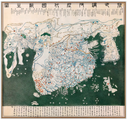 |
| Honilgangni Yeokdae Gukdo Jido - Replica at the Kyujanggak Institute of Korean Studies, Seoul National University |
Geographical Innovation of Joseon
The Honilgangni Yeokdae Gukdo Jido played a crucial role in shaping the world map of its time. One of the most striking features of this map is its recognition of the Earth’s spherical shape. Before the Age of Exploration, most of the Old World still did not perceive the Earth as round, and many maps contained significant errors in terms of orientation and geographical accuracy. However, Joseon, based on a worldview centered around the Korean Peninsula, accurately positioned India and China while meticulously drawing Europe and Africa, showcasing a geographical innovation ahead of its time.
This map avoids the geographical distortions that would have been inherent in the Mercator projection and reflects the Earth’s spherical shape by naturally incorporating Europe and Africa into its depiction. At a time when European maps still depicted distorted versions of these continents, the Honilgangni Yeokdae Gukdo Jido stands out for its geographical accuracy.
Accurate Depiction of Europe and Africa
Particularly noteworthy is the representation of the southern tip of Africa, which differs sharply from European maps of the period. While European maps often misrepresented the southern tip of Africa or oriented it toward the east, the Honilgangni Yeokdae Gukdo Jido accurately shows it facing south, exemplifying its superior geographical precision. The map also accurately portrays major geographical features of Africa, such as Mount Kilimanjaro and the Cape of Good Hope, making it one of the earliest maps to depict the key terrains of Africa.
Europe is depicted with remarkable detail, including key nations like Turkey, Greece, Italy, France, and Germany. The map also includes the Islamic regions and the Middle East, marked with specific Arabic names. Notably, cities in the Middle East, such as Cairo, Baghdad, and Jerusalem, are written in Chinese characters, adding to the map’s unique historical and cultural value.
 |
| The Only World Map of Its Time to Accurately Depict Europe, Africa, and the Middle East |
Joseon’s Global Vision
This map is not just a geographical record but also a reflection of Joseon’s global vision. During this period, Joseon engaged in active diplomatic and commercial exchanges with Europe, the Arab world, China, and Japan, and sought to portray a broad, global perspective. An important aspect of the Honilgangni Yeokdae Gukdo Jido is its emphasis on a Joseon-centered worldview. The Korean Peninsula is placed at the center of the map, symbolizing Joseon’s cultural pride and its position in the world.
Joseon’s Compass and Geographical Accuracy
The creation of the Honilgangni Yeokdae Gukdo Jido was not limited to geographical knowledge alone. Joseon had already invented its own compass, enabling the accurate measurement of direction and location. This innovation allowed for the precise orientation of the map, with directions clearly marked according to true north, south, east, and west. This was a groundbreaking development in the field of cartography at the time and stands as a testament to Joseon’s scientific and astronomical achievements. The map represents a crucial step forward in advancing global geographical understanding.
 |
| The Portable Angbu-ilgu: A Timepiece and Compass Invented During the Reign of King Sejong |
The Historical Value of the Honilgangni Yeokdae Gukdo Jido
This map is a key symbol of Joseon’s vision of the world during the early 15th century, representing both its geographical and scientific achievements. King Taejong commissioned the creation of the map to publicize the historical significance of the Joseon Dynasty and to demonstrate the kingdom's diplomatic stature and global vision. The map’s role extended beyond domestic concerns, acting as a symbol of international exchange and connections.
The map reflects Joseon’s interest in a vast geographical area, encompassing Europe, Africa, and other regions, marking it as a unique artifact that stands apart from other maps of the time. It not only serves as a record of the kingdom’s position but also symbolically represents Joseon’s desire to share its place in the world with others. The Honilgangni Yeokdae Gukdo Jido is therefore a significant testament to Joseon’s international perspective and scientific achievements.
Conclusion: A Historical Legacy and Contemporary Significance
The Honilgangni Yeokdae Gukdo Jido extends beyond being a mere historical artifact; it has had a profound influence on modern cartography and geographical understanding. This map is not just a relic of the past but a groundbreaking work of geographic innovation that has shaped the way we understand the Earth’s shape and the placement of nations. It symbolizes Joseon’s remarkable scientific and cultural achievements and remains a vital intellectual heritage, reflecting East Asia’s global influence that can still be felt today.
As Gwon Geun, the map’s author, aptly stated:
“The world is vast; one can understand the world without leaving home. It is beneficial for governance.”
This quotation highlights the power and global insight embedded in the map. The Honilgangni Yeokdae Gukdo Jido did more than simply depict geography; it opened a new perspective for its viewers, offering them a way to see the world in a broader context. Today, it continues to inspire us to view the world with a wider lens, encouraging a deeper understanding of our global connections.
References
-
Lee, Sang-kyu. Honilgangni Yeokdae Gukdo Jido and Joseon's Cartographic Technology, Korea University, 2020.
-
Park, Young-su. Cartographic Practices and Astronomical Foundations in the Joseon Dynasty, Seoul University Press, 2015.
-
Kim, Min-su. The Honilgangni Yeokdae Gukdo Jido: Global Historical Significance, National Central Library, 2018.
-
UNESCO. Memory of the World: Honilgangni Yeokdae Gukdo Jido, UNESCO, 2019.
-
Namu Wiki: Honilgangni Yeokdae Gukdo Jido, 2025.


Comments
Post a Comment